The project’s general objective is the preparation of a Heritage Charter and includes carrying out systematic studies as a contribution to the management of the maritime and underwater cultural heritage of the Bay of Colonia del Sacramento and its insular environment.
The Heritage Charts are recognized management instruments, which contain the result of the historical-archaeological and ethnographic survey of a region, in order to produce an inventory of its heritage elements, suggest preservation mechanisms and measures for the enhancement of these cultural resources. Given the needs established in the Management Plan for the Historic Neighborhood of Colonia del Sacramento (MEC, 2012) and the lack of previous systematic studies, the project was designed to generate a baseline of knowledge related to the subject, through: a) identification and evaluation of coastal and submerged cultural assets; b) documentation of social practices and perceptions linked to the aquatic environment; c) development of specific techniques for the preservation of local submerged heritage; and d) systematization of knowledge and its presentation in an accessible way to technicians, managers and the general public.
The project is funded by the National Agency for Innovation and Research ANII (ANII FMV 1_2019_1_155671) and is linked to the agreement signed between the Universidad de la Republica and the Colonia’s District for this purpose (Udelar-IC Agreement n.6271/2019) . This project is also approved by the National Cultural Heritage Commission – MEC (EXP: 2020-11-0008-0052) and by the National Naval Prefecture – MDN (PRENA Resolution 140-2021) and has the support of the Municipality of Colonia through the Culture Office and of Planning and Heritage Office.
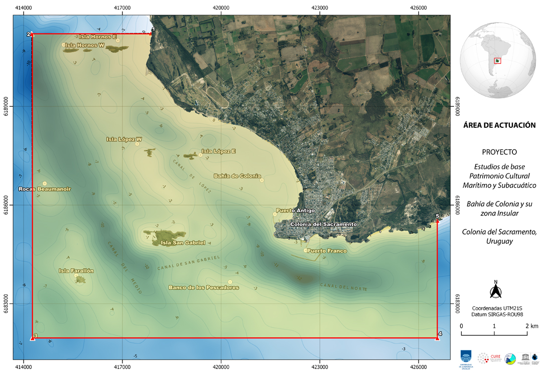
The study area for this project corresponds to the Fluvial Buffer Area proposed in the 2012 Management Plan for the Historic Neighborhood of Colonia del Sacramento, and is comprised by the polygon of vertices:
Point 1 (Hornos Este): 34° 25 ́ 00 ́ ́S / 57° 53 ́ 42 ́ ́W;
Point 2 (Hornos Oeste): 34° 25 ́ 00 ́ ́S / 57° 55 ́ 30 ́ ́W;
Point 3 (Farallón): 34° 29 ́ 18 ́ ́S/ 57° 55 ́ 30 ́ ́W;
Point 4 (Pta. Negra): 34° 29 ́ 18 ́ ́S / 57° 46 ́ 42 ́ ́W.
In the area are the shores of the historic quarter, the Bay of Colonia and the San Gabriel Islands, Farallón, the islets of Los Ingleses and Los Muleques, the islands of Antonio López and Hornos, an environment that includes important historical records. The study area also corresponds to the polygon established in 2005, when the Bay of Colonia and its Insular zone were included in the Tentative List for nomination to Cultural Heritage of Humanity by UNESCO. (UNESCO, 2005 Ref. 2034).